rectif is a free command-line tool for image rectification.
It provides the possibility of metrical measurements in the rectified image-plane.
Once a transformation is processed, Euclidean measurements,
such as lengths and angles, can be made directly from the image.
In addition, the perspective will be rectified to one
that would have been obtained from a front-parallel view.
The program is able to process JPEG images and ASCII point-files. A rectified
png-image, as well as a corresponding world-file will be generated.
usage
Four corresponding point-sets are required and can be digitized manually
within image processing software, such as the open source software GIMP.

single point digitized within Gimp

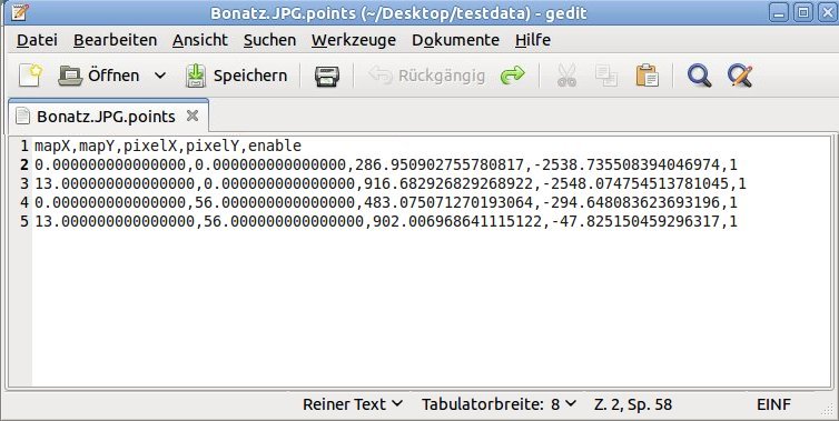
regular point file format
For the first trial a data sample is available, too.
Regular syntax: $ rectif Bonatz.JPG
If available - the open source georeference-plugin which is included in
Qgis can be used.

points digitized within Qgis
Qgis point file format
Qgis syntax: $ rectif Bonatz.JPG q
reference
If you use this software in your own projects, please cite the reference below:
U. NIETHAMMER, S. ROTHMUND, M. JOSWIG:
UAV-based remote sensing of the slow moving landslide Super-Sauze,
LANDSLIDE PROCESSES, ISBN 2-9518317-1-4, CERG Editions, Strasbourg 2009: 69-74 & 352